Union Banks, Johnson South Reef, Sin Cowe, Hughes Reef, Whitsun Reef, Spratly Islands
The first is Union banks 1, or Johnson South Reef a.k.a. Chigua Jiao (Chinese), Mabini Reef (Philippines) and Da Gac Ma (Vietnamese). According to Wikipedia, this island is occupied by the PRC, but is also claimed by Philippines, ROC and Vietnam./ It is just Southeast of Collins Reef, which is occupied by Vietnam.
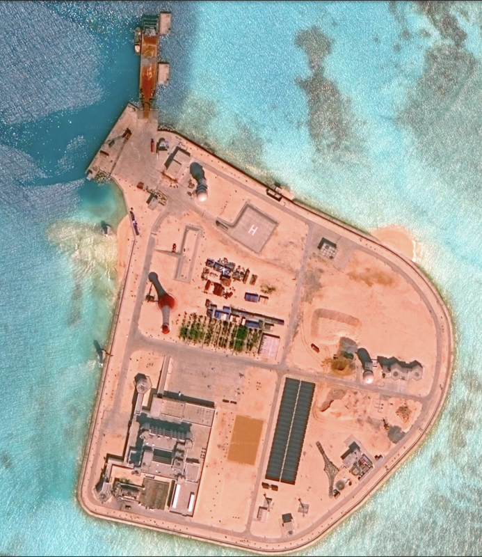
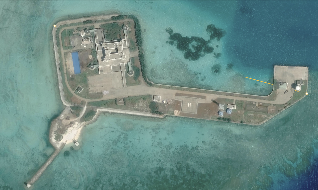
Union Banks 1, or Johnson South Reef, has a well developed man-made island. Just north of the island we saw a navigation tower and a ship. The island itself has a few tall structures, two balls on towers, a navigation light, a dock, and a helipad. Not much else, this looks like a work yard with one large building complex, and a port with a large crane. Location: 9°42'57"N 114°17’11"E. Looks like a transit yard. Satellite Imagery 11/6/2015, or approximately eight years ago. It looks like a small, well-defended workyard in the middle of the ocean. There was a military skirmish over this island on March 14, 1988 between China and Vietnam since Vietnam at the time occupied islands in the Union Banks such as Sin Cowe Island.
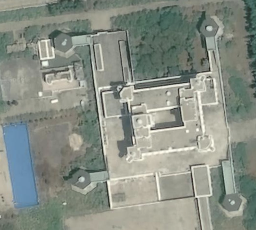
It does have one of those buildings we have seen before in the Spratly Islands with turrets attached to the corners (this time only two on the sides closest to the water), and a ramp leading into the building above ground level, and a significant and multi-floor courtyard. Diameter: 0.33 miles.
According to Wikipedia, in 1987 the ROC had a South China Sea island under occupation, but the PRC did not. That was to change under a UN IUNESCO IOC mandate to establish an observation post in the South China Sea. At that time, Johnson South Reef and Fiery Cross Reef were potential PRC islands, along with Mischief Reef a few years later in 1994.
Johnson South Reef has a past between China and Vietnam, and a series of armed battles and skirmishes culminating in the March 14, 1998 skirmish between naval and marine forces. By the end, China had killed approximately 70 Vietnamese naval personnel and established control over the island. According to Wikipedia, the Vietnamese were inhabiting and creating presence and territorial domain over the islands of Union Banks, and nearby on islands such as Fiery Cross (also currently occupied by China), when China started establishing their own outposts. This was based on the 14th UNESCO Intergovernmental Oceanogfraphic Commission (IOC) that ordered that China establish five observation posts for worldwide ocean survey, including one in the Spratly Islands in 1987.
In 1994, according to Wikipedia, a similar confrontation occurred when China assetted its ownership of Mischief Reef against the Philippines. In this case, the Philippines made a political protest and did not engage militarily, and now Mischief Reef is a fully militarized PRC island.
Moving South to North, we see infrastructure only (a pair of structures connected by a bridge), Gent reef, which shows reclamation and a sandy spit of land, but no infrastructure. Both have satellite imagery dated 2/10/2021, North of that we see Loveless Reef, which appears to have significant but very early stage reclamation occurring. Satellite imagery also dated 2/10/2021. Then we pass Sin Cowe to the Northeast. Then East of Sin Cowe we have Edmund Reef with a tiny sand spot dated 3/9/2021. Moving East further is McKennan Reef, which is a sand spit of land that looks like an ear, dated 3/9/2021. Some of these locations, such as Collins Reef, have navigation channels carved into the reefs near the infrastructure elements.
Collins Reef, a.k.a. Johnson North Reef, is also Vietnamense controlled and is the westernmost feature of the Union Banks Atoll.
Union Bank 3
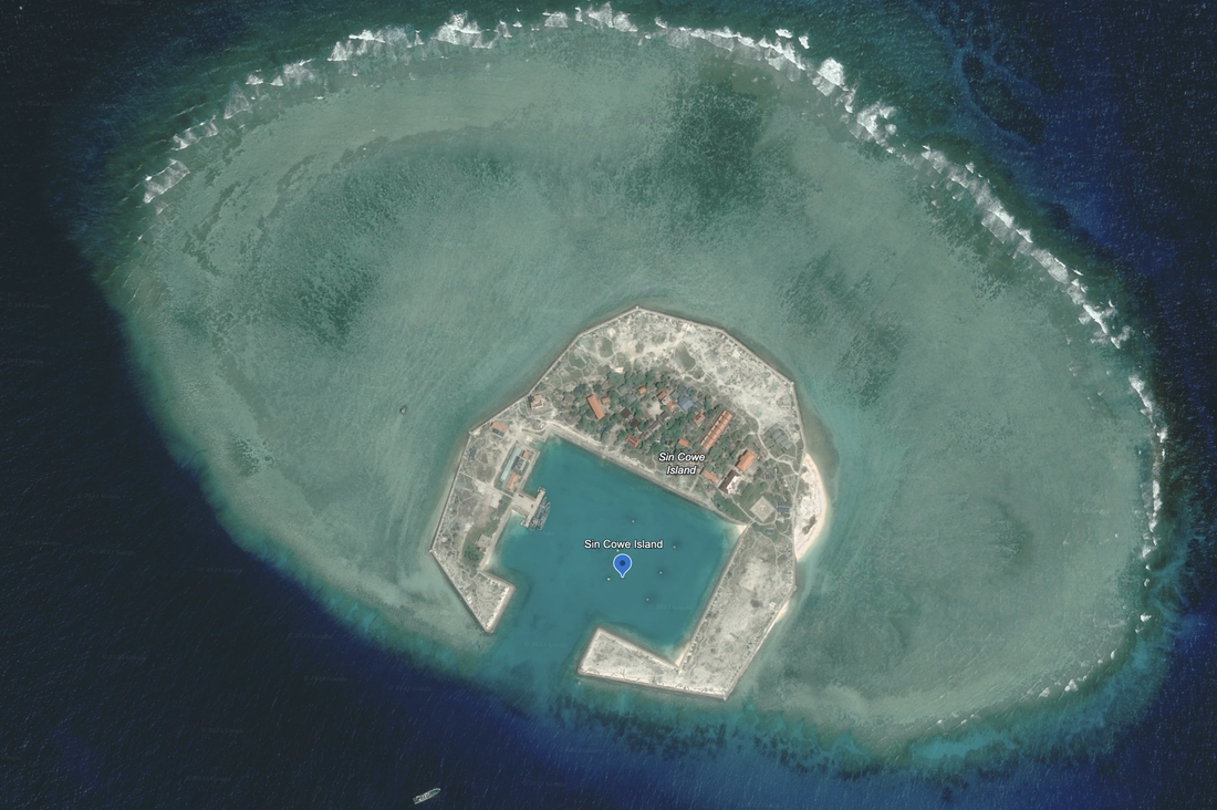
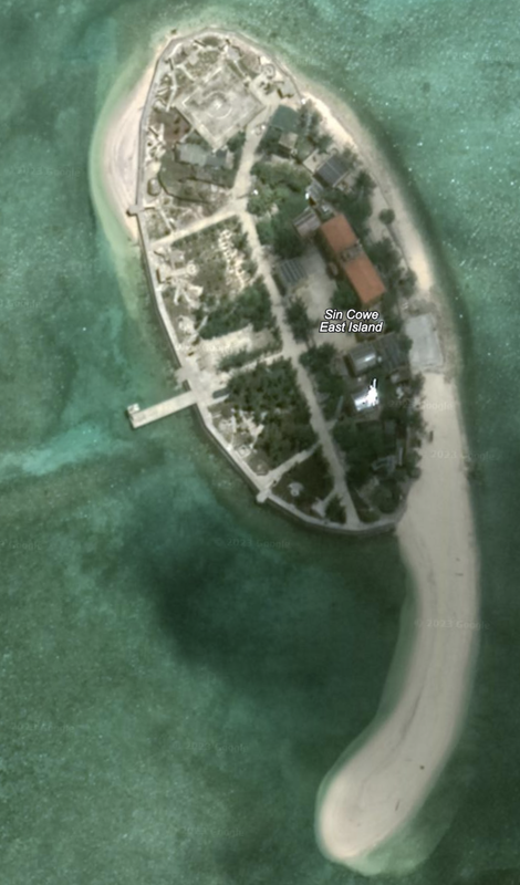
Sin Cowe, a.k.a., Sinh Ton Island or Dao Sinh Ton (Vietnamese), Rurok Island or Island of Peak (Philippines), and Jinghong Dao (Chinese) is occupied by Vietnam. It is also claimed by PRC, Philippines and ROC.
Sin Cowe island has a protected bay / cove and a small island around it on 3.5 sides. It sits atop a much larger, shallow shoal so we would expect over it to grow through land reclamation. Satellite imagery 3/9/2021. It is almost a perfect 0.31 mile square. It has a helipad, and most of the land is not yet developed. We see a seawall surrounding the entire island, and two ships tied up at the dock. The buildings look somewhat random and non-descript.
Location: 9°53'08"N 114°19’46”E.
After zooming in, we see that about half the island is undeveloped, and the other has about 30 structures on it, and a good landscaping of trees, in an otherwise sandy island. The island has a single helipad. The dock facilities look small, and we see two ships moored together, side by side, at the one pier space.
According to Wikipedia, there is both a civilian and military population.
Hughes Reef
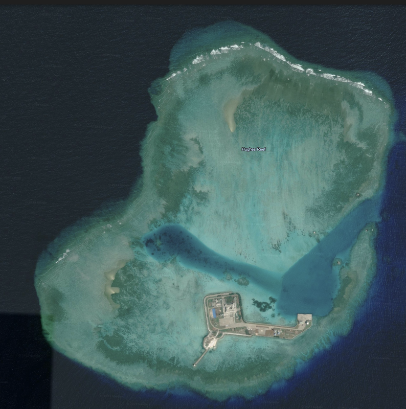
Hughes Reef a.k.a. Dongmen Jiao (PRC), da Tu Nghia (Vietnamese) is occupied by the PRC. It is claimed by the PRC, ROC, Philippines, Malaysia and Vietnam, according to Wikipedia.
This is a small island (0.39 mile diameter from East to West) with a significant dock, three radomes, a tall radio tower, a helipad, a navigation light, and one of those buildings with the four turrets sticking out of the corners (with cannons on the four roofs), the ramp leading up into the building above the ground floor, and a significant courtyard. Satellite Imagery is dated 3/9/2021, and the location is 9°54'35"N 114°29'43"E.
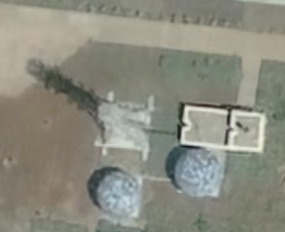
Hughes Reef has a significant protected cove shaped like a dogleg right that is marked by navigation lights before getting to the island. It is a small island with one building complex and four tall, raised anti-aircraft cannon turrets at the corners. The island then has a concrete pier, three radomes on towers, and some navigation lights. It also has a helipad.
We notice a rectangular shape carved into the group on the eastern side of the island, and we have seen something like this, although covered in a blue tarp, on two other PRC islands.
Finally, Hughes Reef has additional land reclamation efforts underway in the northern part of the reef, so this island may be in line for growth.
|
|
|
|
The sixth island is Sin Cowe East island, with a small oval core, and a long tail of newly reclaimed land to the south. We also see a dock perpendicular to the Western side of the island. Satellite imagery dated 4/29/2019, and we see a helipad on the northern end of the island. Island diameter is 0.22 miles, including the sandy tail.
This is a small island with one large building, a few more smaller buildings along one main street, and a helipad. It looks like the island is being extended to the South, and may become more than twice the size. This picture is from 04/29/2019.
We have read that Sin Cowe East is a an island of focus by Vietnam and will receive investment.
Union Bank 6 is a natural reef, named Lansdowne Reef, with two infrastructure element on it connected by a bridge. It looks like these infrastructure elements are kicking up a lot of sand, and that sand is filling in the open water inside the reef (center of the overall picture). I wonder if this is what those two structures are made for, for bringing up sand from the ocean floor.
It looks like Lansdowne Reef is being reclaimed and turned into an island as we watch. This satellite photo is from 02/10/2021, or almost three years ago.
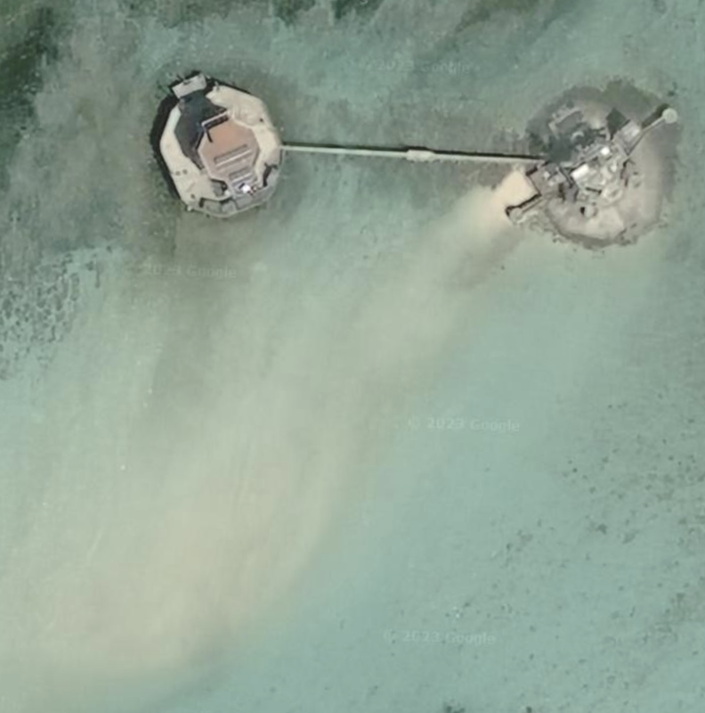
This is a busy neighborhood, and we learned that on December 3, 2023, the Philippines monitored the presence of 135 Chinese maritime militia vessels in the vicinity of this reef. The reef was unclaimed as of 2016, but on March 21, 2021, about 220 Chinese fishing ships were moored at the reef, according to Wikipedia.
Name 1
Nearest Land
Distance from Land (miles)
Location (latitude & longitude)
Diameter (miles)
Date of Satellite Imagery
Airport Present?
Helipad Present?
Port / Dock Facility Present?
Buildings Present?
Defensive Infrastructure Present?
Athletic Facilities Present?
Hospital Present?
Sand Only Island?
Dredging Infrastructure Only?
Spratly Islands
Union Banks (with 4 developed and ~12 early stage)
Vietnam
206
9°42'57"N 114°17’11"E
34.5
11/6/2015
No
Yes
Yes
Yes
No
No
No
Yes (on some)
Yes (on some)
Consulting Session
This is a one-hour meeting, remote or in-person, with Jeffrey Cohen, President of U.S. Advanced Computing Infrastructure, Inc.
You choose the topic and deliverables.
You may buy multiple hours to fund a project.
We believe management consulting is pursuing "the art of the possible." These are areas where we believe we may be helpful:
- We will discuss our research into the South China Sea
- We offer traditional IT management consulting services.
- We offer quantum computing consulting
- We offer financial investment analysis of stock portfolios based on our Chicago Quantum Net Score (read more in our published research). Today we run a model that analyzes ~3,000 U.S. listed equities and optimizes both 'long' and 'short' stock portfolios.
- Project and program management.
- Outsourcing advisory.
- We run your business problem on our discrete mathematical models (on our own server equipment using our own solvers).
- We may configure and run your problem on quantum annealing computers from D-Wave Systems Inc.
- We ALWAYS work confidentially, diligently, free of conflict of interest, and bring our best thinking and insights.
We can operate at both the strategic and tactical level depending on client need. This includes business strategy, business problem decomposition, mathematical and data design, algorithm design, and use of quantum and classical solvers. The President has a strategic perspective from ~ 30 years of executive corporate management in IT and professional services, and also rolls up his sleeves and codes when there is a good fit with the problem and his expertise.
Absolute discretion and professionalism is assured.
In closing
If you would prefer to discuss this 1:1 and negotiate a scope of work and level of effort, please contact us at jeffrey@quantum-usaci.com or call (312) 515-7333. We will develop a quotation and will invoice for our services.